


This page is a "proof of concept" experiment designed to demonstrate the possible utility of using Google Earth to add a geographic/spatial dimension to our genealogical information.
Genealogy buffs have been photographing gravesites of ancestors as part of the dossier on their ancestors for many years. Some people have even made a hobby out of photographing gravestones in local cemeteries and they are now being posted on the Web. See:
findagrave.com
which lists cemeteries worldwide, although most listings are in the US. It's free. For example, you can find a photograph of Allen Rosenkrans' grave (he died in 1906) in Newton Cemetery, Newton, New Jersey.
More recently, they have also been including the GPS (Global Positioning Sytem) data (latitude and longitude) to accurately pinpoint the location of the grave. A digital camera and a GPS device, both of which have come down greatly in price in recent years, are now commonplace for most people.
Instructions
This page contains geographic information associated with Allen's text. You must download and install Google Earth in order to use it.
Downloading KMZ Files From This Page
Each section is headed by a title followed by a map of the area. Below the map is a Placemarks label. Clicking the Placemarks label, which is a hyperlink, will download a KMZ file that contains the placemarks listed underneath the label and displayed on the map. You will first see the following window:

Save this file on your hard drive.
Importing KMZ Files From Your Hard Drive Into Google Earth
Open Google Earth, and click File>Open. Navigate to the KMZ file you just stored and click on it. Google Earth will copy the Placemarks into Temporary Places in your Places Menu and "fly" you to the area containing the Placemarks. Double click on any Placemark to "fly" to that Placemark.

Google Earth will add the new file to your Temporary Places and "fly" you to a location that shows all of the items in the file that you just imported:
In addition to Placemarks, Google Earth can be used to create Paths to show routes taken and Polygons (closed Paths) for outlining area boundaies. It can also be used to create a directory structure to organize and contain these items.
Europe
This file contains Placemarks for Eurpean capitals and other locations mentioned in first part of Allen's book prior to the generational listings.
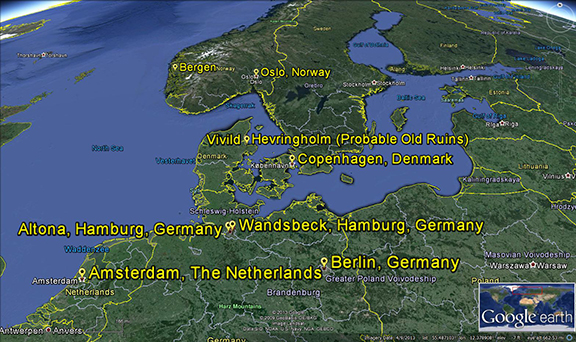
- Europe
- Holland
- Amsterdam
- Germany
- Berlin
- Altona, Hamburg
- Wandsbeck. Hamburg
- Denmark
- Copenhagen
- Vivild
- Hevringholm (New)
- Hevringholm (Probable Old Ruins)
- Norway
- Oslo
- Bergen
- Holland
First Generation
Placemarks in this section refer to places in Ulster County, New York, that are associated with Harmon Hendrick.

- Ulster County Boundary
- Rochester Township (formerly Mombaccus) Boundary
- Old Dutch Church, Kingston, New York
- Site of Harmon's Homestead, Alligerville, New York